Last updated:
10th February 2026
Woodley to Reading Active Travel Route design
This final design follows multiple rounds of consultation and was shaped by the feedback We received, addressing most of the points raised while meeting the funding requirements of Active Travel England (ATE).
Woodlands Avenue East (Woodley town centre to Howth Drive)
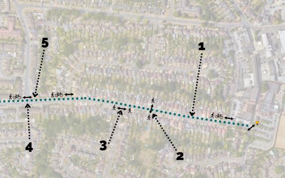
1. A two-way segregated cycle track along the northern side of Woodlands Avenue will be 2.3 metres wide, taking space from existing verges.
The road will remain two-way and 5.5 metres wide, replacing earlier proposals to narrow it to 5 metres or make part of it one-way. The verges and footway on the south side will be largely kept, except for a narrow verge between Woodwaye and Howth Drive.
2. A raised table foot crossing leading to the path to Woodwaye will be provided in response to consultation feedback.
3. There’ll be continuous footway crossings at each side road to enforce the existing pedestrian priority and encourage drivers to give way.
4. The mini-roundabout on Howth Drive will become a T-junction with a cycle track crossing over the northern arm. The lay-by opposite will be reduced to one vehicle space to make turning easier and improve drainage.
5. As long as Reading Borough Council agree, we aim to plant on green space next to Howth Drive to make up for the loss of trees.
Additionally, subject to a Traffic Regulation Order, the speed limit on Woodlands Avenue will be reduced to 20mph limit and double yellow lines will be painted to restrict parking from the zebra crossing near the shops until just past Fairwater Drive. The zebra crossing near the shops will also be refurbished.
Woodlands Ave West (Howth Drive to Church Road)
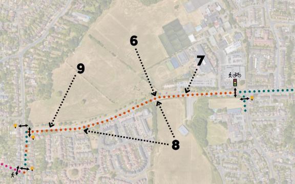
6. The existing shared use path along this section of Woodlands Avenue will be kept, based on your feedback that it’s fine as it is.
7. The Addington School entrance will remain in its current form.
8. Additional zebra crossings could be built on this section of Woodlands Avenue in future, if funding becomes available, but aren’t currently proposed.
9. Existing laybys will be kept and We’re no longer proposing to remove parking in this section, again in response to concerns.
Additionally, a new toucan crossing will replace the existing pelican crossing to the west of Fairwater Drive. The uncontrolled side crossing on Fairwater Drive will be upgraded to a zebra crossing.
Two more zebra crossings will be installed near the junction of Woodlands Avenue and Church Road – one to the east, on Woodlands Avenue, and another on Church Road to the north of the junction.
Church Road, Palmerstone Road and Culver Lane
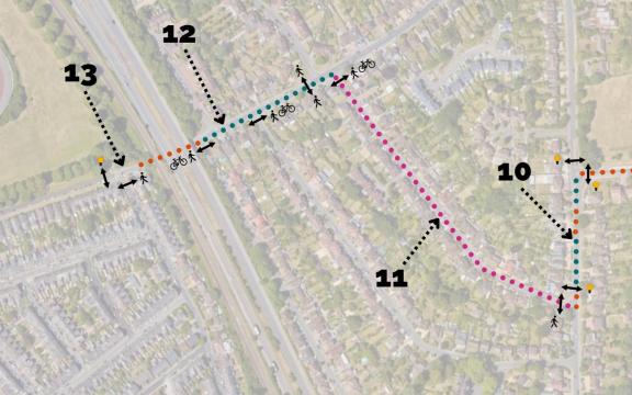
10. The route will emerge onto Church Road, to the south of Woodlands Avenue. There’ll be sections of two-way segregated cycleway along the eastern side of Church Road except at pinch points, where it will be shared use.
The route then proceeds west along Palmerstone Road, in response to feedback showing a clear preference for this over Anderson Avenue.
11. The cycle track stops at the Palmerstone Road junction and a continuous footway crossing will be adjusted to join the existing layout. There’ll also be a new zebra crossing on Church Road, immediately north of the Palmerstone Road junction.
No physical changes are proposed to Palmerstone Road but, subject to a Traffic Regulation Order, the speed limit on Palmerstone Road and this section of Culver Lane will be reduced to 20 mph zone in line with best practice.
12. A segregated two-way cycle track will run along the southern side of Culver Lane until the railway and A329(M) overbridge. All side road junctions on the south side of Culver Lane will be improved to enforce cyclist and pedestrian priority.
There’ll also be a new raised table foot crossing across Culver Lane, immediately west of the junction with Milton Road.
13. Subject to a Traffic Regulation Order, double yellow lines will be painted to restrict parking along both sides of Culver Lane.
Existing parking bays west of Culver Lane will be kept, and there’ll be a short section of shared use under the bridge following consultation feedback. Due to the narrow road under the bridge, westbound motor vehicles will give way to oncoming traffic.
At the end of the route near Palmer Park, there’ll be a pedestrian/cyclist priority side road crossing on Wykeham Road and a new pedestrian/cyclist zebra crossing across Palmer Park Avenue to the west of that.


